model a real space on a coordinate grid, compute perimeters and areas, partition paths, model a coverage zone with a circle, and prove properties of figures on the map with coordinates.
Instruction
City planners, surveyors and game designers all do the same thing: put a real place on coordinates and let algebra answer questions about it. This project asks you to do that with a place you know.
Build the map. Choose one route; all three earn full credit and all three support every computation and proof below.
- Route A — Measure a place yourself. The school campus, a park, a block of your neighborhood, or a floor plan of a public building. Pace the distances (count your paces over a measured 10 m first, so you know your pace length) or use a free online map with a scale bar. Choose an origin, a corner of a building works well, orient the axes, and state your scale, for example 1 unit = 10 m. Mark at least eight labeled points with coordinates.
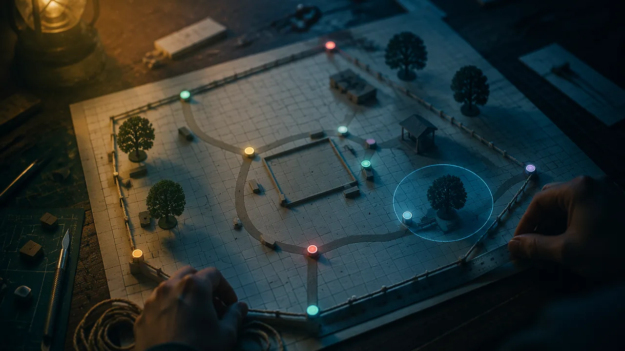
- Route B — Use the printed site plan below. Riverbend Community Park, an illustrative site plan built for this task, at a scale of 1 unit = 10 m. Nothing to measure and no internet needed.
The fenced park is the pentagon GPRKT; ABCD is the skate plaza inside it. Check your work as you go: the pentagon’s area is 147 square units, which is 14,700 m2, and its perimeter is about 47.25 units, about 472.5 m. ABCD has area 24 square units, or 2,400 m2. A sprinkler at (5, 5) with a radius of 4 units covers a bench at (2, 4) but not the kiosk.Point G gate P parking corner R restroom K kiosk T trailhead A B C D Coordinates (0, 0) (14, 0) (14, 9) (6, 12) (0, 9) (2, 2) (8, 2) (10, 6) (4, 6) - Route C — Use a published map. The USGS National Map viewer (apps.nationalmap.gov/viewer) gives you a public-domain map with a stated scale for anywhere in Missouri; a state or county park’s published trail map with a scale bar works just as well. Cite the map and its scale, then place your own axes on it and read off at least eight points.
Required computations.
- Perimeter and area of two regions, one of them not a rectangle. Use the distance formula for sides; find area by splitting into triangles and rectangles or by enclosing in a rectangle and subtracting corner triangles. Convert to real units with your scale (remember that areas scale by the square of the scale factor).
- Partition. Locate a point on a real path (say, from the gate to the gym) that divides it in a ratio that means something: a bench one-third of the way, or a meeting point that splits a walk 2:3 between two friends. Show the computation and check it with distances.
- Coverage circle. Model a sprinkler, Wi-Fi router or emergency siren as a circle with a stated center and radius. Write its equation in standard form, expand it to general form, and then show that completing the square recovers the center and radius. Decide with the equation whether two named points on your map are covered.
- Lines. Write the equation of one path on the map and of a new path you propose that is perpendicular (or parallel) to it through a given point, using the slope criteria.
Required proofs.
- Prove, with the coordinates from your map, what kind of quadrilateral one four-sided region is (parallelogram, rectangle, trapezoid, rhombus or none), using slopes and distances.
- Write one general coordinate proof from the unit (for example, the diagonals of a parallelogram bisect each other, or the midpoint of the hypotenuse is equidistant from the vertices), with a sentence explaining why your placement loses no generality.
Precision. Keep exact radicals until the last step, state units on every answer, and round real-world answers sensibly.
Privacy. You never have to map your home, and none of the three routes asks you to. Route B needs no place at all.
Presentation. Three minutes, live or recorded: show the map, walk through one computation and one proof.
📖 Read for this lesson
The reading opens over the lesson; close it to come back to exactly where you were. The checks below draw on it.
Formative check
Work through these before moving on. They are not graded — they tell you whether the standard below has landed yet.
Area of a triangle with no side on an axis
Tap to revealEnclose it in a rectangle and subtract the corner right triangles, or split into triangles with known base and height.
Point 1/3 of the way from A to B
Tap to revealA + (1/3)(B − A), coordinate by coordinate.
Map scale 1 unit = 10 m: 1 square unit of area is…
Tap to reveal100 m².
Proving a quadrilateral is a rectangle
Tap to revealShow it is a parallelogram and one angle is right (slopes with product −1), or show all four angles are right.
On a map with scale 1 unit = 10 m, a region has area 12 square units. What is its real area?
Stage 1: describe your chosen space, your scale and origin, and list the coordinates of at least eight labeled points. Name the region you expect to be a special quadrilateral and what you will need to show.
How confident are you that you can model a real space with coordinates and prove and compute with it?
Unit 2 checkpoint
Do this before you start the task. It covers the whole unit and tells you what to review first.
The circle (x + 4)² + (y − 1)² = 49 has center and radius:
x² + y² − 8x + 6y = 0 has radius .
Which slope is perpendicular to 3/4?
Distinct lines with equal slopes are parallel.
The point 1/4 of the way from (0, 0) to (8, 12) is:
The point partitioning the directed segment from (1, 1) to (7, 10) in the ratio 1:2 is (3, ).
The distance between (−1, 2) and (5, 10) is:
The triangle with vertices (0, 0), (8, 0) and (3, 5) has area .
Checking one numerical parallelogram proves that the diagonals of every parallelogram bisect each other.
The parabola with focus (0, 4) and directrix y = −4 is:
The parabola x² = 24y has its focus at (0, ).
Quadrilateral (0,0), (4,1), (5,5), (1,4) is a square.
Submit: Coordinate Proof and Mapping Project with three-minute presentation
Task: Place a real space on coordinates at a stated scale. Compute two perimeters and areas, a partition point, a coverage circle and a perpendicular or parallel path, then prove the classification of one quadrilateral with your coordinates and write one general coordinate proof.
Submission workflow
- Stage 1 — Plan. Chosen space, scale, origin and axes, and a labeled sketch with at least eight points.
- Stage 2 — Peer-reviewed draft. All computations and both proofs; a partner re-computes one area and checks the general proof for hidden assumptions. Submit a revision note.
- Stage 3 — Revised final. Finished map with computations in real units and both proofs.
- Stage 4 — Presentation. Three-minute live or recorded walkthrough of one computation and one proof.
How it is scored
| Criterion | What proficient looks like |
|---|---|
| Perimeter and area (G.GPE.B.6) | Correct distance-formula perimeters and decomposition areas, converted to real units with the square of the scale. |
| Partition (G.GPE.B.5) | Meaningful ratio; correct point; checked by distances. |
| Circle (G.GPE.A.1) | Standard and general forms correct; coverage decisions justified. |
| Lines (G.GPE.B.4) | Perpendicular or parallel path found correctly with the slope criteria. |
| Proofs (G.GPE.B.3, MP.3) | Classification proved completely; general proof valid with justified placement. |
| Precision (MP.6) | Exact values kept until the end; units and rounding appropriate. |
Two Maps on Coordinates: Riverbend Park Fully Worked, and Five Real USGS Gauges Around St. Louis
USGS National Water Information System, site file for stations 07010000, 06935965, 07019000, 07010097 and 07010022 (decimal latitude and longitude, NAD83), retrieved Nov. 5, 2026; the Riverbend Community Park site plan is SLS original teaching data · Public domain (U.S. Geological Survey coordinates), with SLS original worked examples and the illustrative site plan
Why this reading. The task’s Route B prints nine coordinates and four check values and stops. Here is every one of those check values reproduced step by step, so that when your own numbers disagree you can see where. Then a second map: five real gauging stations on the Mississippi, Missouri and Meramec Rivers and the River Des Peres around St. Louis, with the coordinates the U.S. Geological Survey publishes for them, converted to a kilometer grid. It is a Route C map that needs no internet and no measuring, and its coordinates are real.
Map 1. Riverbend Community Park (illustrative), 1 unit = 10 m
G(0, 0), P(14, 0), R(14, 9), K(6, 12), T(0, 9); skate plaza A(2, 2), B(8, 2), C(10, 6), D(4, 6).
Perimeter of GPRKT. GP = 14, PR = 9, RK = √((14 − 6)2 + (9 − 12)2) = √73 ≈ 8.544, KT = √(36 + 9) = √45 = 3√5 ≈ 6.708, TG = 9. Total 14 + 9 + √73 + 3√5 + 9 ≈ 47.25 units = 472.5 m.
Area of GPRKT. Split it into the rectangle GPRT (14 by 9, area 126) and the triangle TRK on top (base TR = 14, height 12 − 9 = 3, area 21): 147 square units = 147 × 102 = 14,700 m2. Check by enclosing in the 14-by-12 rectangle (168) and subtracting the two corner triangles beside K: ½ × 6 × 3 + ½ × 8 × 3 = 9 + 12 = 21. Again 147.
ABCD. AB and DC are both horizontal (slope 0) with length 6; AD and BC both have slope 4/2 = 2 and length √20. A parallelogram. Not a rhombus (6 ≠ √20), not a rectangle (a horizontal side and a side of slope 2 are not perpendicular). Area = base × height = 6 × 4 = 24 square units = 2,400 m2.
Sprinkler. (x − 5)2 + (y − 5)2 = 16; general form x2 + y2 − 10x − 10y + 34 = 0. Bench (2, 4): 9 + 1 = 10 < 16, covered. Kiosk (6, 12): 1 + 49 = 50 > 16, not covered. Completing the square on the general form must return center (5, 5) and radius 4.
A partition and a line. One-third of the way from the gate G to the kiosk K: (0 + 2, 0 + 4) = (2, 4), the bench. The path from T(0, 9) to P(14, 0) has slope −9/14; a new path through K perpendicular to it has slope 14/9, equation y − 12 = (14/9)(x − 6).
Map 2. Five USGS gauges on real coordinates
The USGS publishes the latitude and longitude of every stream gauge it operates. These five are in St. Louis County, St. Louis city and St. Charles County. To turn degrees into a flat kilometer grid, take the Mississippi River gauge at St. Louis as the origin and use 111.2 km per degree of latitude and 111.2 × cos(38.63°) ≈ 86.87 km per degree of longitude at this latitude. The grid is an approximation of a curved surface, good to a few tenths of a kilometer over these distances; say so in your report.
| Point | USGS site | Station name (as published) | Latitude | Longitude | East (km) | North (km) |
|---|---|---|---|---|---|---|
| F | 07010000 | Mississippi River at St. Louis, MO | 38.62900 | −90.17978 | 0.0 | 0.0 |
| C | 06935965 | Missouri River at St. Charles, MO | 38.78719 | −90.47181 | −25.4 | 17.6 |
| E | 07019000 | Meramec River near Eureka, MO | 38.50514 | −90.59017 | −35.7 | −13.8 |
| R | 07010097 | River Des Peres at St. Louis, MO | 38.55925 | −90.28328 | −9.0 | −7.8 |
| U | 07010022 | River Des Peres near University City, MO | 38.66856 | −90.32356 | −12.5 | 4.4 |
Worked: U’s east coordinate is (−90.32356 − (−90.17978)) × 86.87 = −0.14378 × 86.87 ≈ −12.5 km; its north coordinate is (38.66856 − 38.62900) × 111.2 = 0.03956 × 111.2 ≈ 4.4 km. The straight-line distance from the St. Louis gauge to the St. Charles gauge is √(25.42 + 17.62) ≈ 30.9 km.
Using Map 2 for the task.
- Perimeter and area. The quadrilateral F-C-E-R, in that order (plot the points first: U lies inside it, which is why it is not a vertex). Compute the perimeter with the distance formula and the area by splitting along the diagonal CR into two triangles. State units: your grid is already in kilometers, so 1 square unit is 1 km2.
- Partition. A survey drone flies straight from F to C; find the point 2/5 of the way, and check it with distances.
- Coverage circle. A radio repeater with a 13 km range placed at U: write its equation and decide which gauges it reaches. Then find the smallest range a repeater at C would need to reach both U and E.
- Lines. Write the equation of the line through U and C, and of the line through E perpendicular to it.
- Classify. Is F, C, E, R a trapezoid? Use slopes to decide, and say which of your answers above is sensitive to the fact that each coordinate is rounded to 0.1 km (look closely at the repeater at U and gauge F).
The gauge coordinates are what USGS publishes; the grid conversion, the drone and the repeater are the exercise. If you use this map, cite the site numbers, and print the station names exactly as the USGS site file gives them.
Sources: USGS National Water Information System, site information for stations 07010000, 06935965, 07019000, 07010097, 07010022 (waterservices.usgs.gov); USGS Water Data for the Nation (waterdata.usgs.gov)